
In un contesto di disponibilità diffusa ed eterogenea di beni trasformabili nel tessuto urbano, non solo di proprietà del Comune, Future Urban Legacy Lab ha proposto un cambiamento di paradigma. Esso integra l’analisi della disponibilità d’uso del patrimonio edilizio comunale con una riflessione sull’intensità d’uso, le dinamiche di trasformazione e il potenziale di transizione. Il fenomeno della disponibilità è inteso come un insieme di relazioni dinamiche tra le componenti dello spazio edificato della città (gli edifici, la morfologia dei blocchi e la loro aggregazione) e non come episodi isolati. Questo approccio consente di collocare gli immobili comunali nel quadro più ampio della disponibilità di beni e spazi utilizzabili a Torino e di arricchire l’interpretazione esaminando anche altri fenomeni urbani.
Attraverso questo quadro di riferimento, il potenziale di trasformazione dei beni viene definito identificando vari indicatori, in grado di fornire informazioni utili per le valutazioni e le strategie di intervento applicabili a beni di diverso tipo e consistenza, andando oltre l’ambito delle indagini iniziali effettuate.
L’interesse del gruppo di ricerca era quello di sviluppare un ragionamento sull’economia dell’intensità di utilizzo e sul profilo di rischio associato al potenziale di trasformazione.
1- Un approccio multidisciplinare
Il centro interdipartimentale dell’Università Politecnica di Torino, FULL (Future Urban Legacy Lab), attraverso il Dipartimento di Architettura e Design, propone di integrare l’analisi della disponibilità all’uso del patrimonio edilizio comunale con una riflessione sull’intensità di utilizzo, le dinamiche di trasformazione e il potenziale di transizione.
Torino è un laboratorio che ha prodotto esperienze in grado di fornire una panoramica su questi temi, come TorinoAtlas e le edizioni del rapporto Giorgio Rota, attraverso studi specifici e settoriali.
In un contesto di disponibilità diffusa ed eterogenea di beni trasformabili nel tessuto urbano, non solo di proprietà del Comune, FULL propone un cambiamento di paradigma. Il fenomeno della disponibilità è inteso come un insieme di relazioni dinamiche tra le componenti dello spazio costruito della città (gli edifici, la morfologia dei blocchi e la loro aggregazione) e non come episodi isolati. Questo approccio consente di collocare gli immobili comunali nel quadro più ampio della disponibilità di beni e spazi utilizzabili a Torino e di arricchire l’interpretazione esaminando anche altri fenomeni urbani.
Attraverso questo quadro di riferimento, il potenziale di trasformazione dei beni può essere definito identificando vari indicatori, in grado di fornire informazioni utili per le valutazioni e le strategie di intervento applicabili a beni di diverso tipo e consistenza, andando oltre l’ambito dei singoli casi di studio.
L’interesse del gruppo di ricerca è quello di sviluppare un ragionamento sull’economia dell’intensità di utilizzo e sul profilo di rischio associato al potenziale di trasformazione.
I processi di rigenerazione possono fallire o non essere avviati nonostante la mobilitazione delle risorse. Riteniamo che la rigenerazione non debba essere prescritta come soluzione unica per tutti gli usi possibili del patrimonio edilizio.
Il fallimento è particolarmente utile per codificare il potenziale, consentendo di ricondurre le ragioni alle caratteristiche intrinseche dell’asset o alle condizioni di gestione.
Nell’analisi del patrimonio costruito, FULL fa quindi riferimento a una specifica valutazione economica, richiesta dal bando, che mappa le ‘opzioni reali’, ovvero le possibilità di intraprendere azioni ‘a rischio’ legate al patrimonio, nonché di differirle in attesa di condizioni contestuali più prevedibili o di rinunciarvi del tutto.
Il metodo proposto da FULL si basa su un approccio transdisciplinare che prevede un confronto continuo e integrato tra tecniche applicate e competenze economiche, gestionali e progettuali, ripristinando i fenomeni urbani attraverso l’analisi di grandi quantità di dati e un focus mirato, al fine di riflettere e operare all’interno della città.
2- Il metodo: misurare, riconoscere, valorizzare
FULL sta sviluppando progetti attinenti alle tematiche sollevate dal bando: preparazione di strategie per la riqualificazione di siti culturali sottoutilizzati, identificandone il potenziale (per la Regione Piemonte); analisi del rapporto tra la distribuzione delle attività commerciali e la forma urbana (con la Camera di Commercio); riorganizzazione dei dati spazializzati su Torino e definizione delle priorità dei codici e dei regolamenti ai fini della rigenerazione (per il Comune di Torino – supporto alla stesura della variante al PRG).
Attraverso esperimenti nel campo della rigenerazione di siti inquinati e l’analisi dei fenomeni urbani, FULL sta inoltre sviluppando piattaforme tecniche per l’integrazione e l’interoperabilità dei dati sulla città, funzionali a un contesto di trasformazione del tessuto esistente.
Sulla base dell’esperienza acquisita, FULL propone un metodo di lavoro sviluppato attraverso:
– Misurare e rappresentare la disponibilità a partire dal patrimonio comunale, spazializzando il fenomeno e mettendolo in relazione con altre dinamiche di utilizzo dell’ambiente costruito.
– Riconoscimento i tipi di beni attraverso la classificazione in base alle categorie di distribuzione, costruzione e morfologia.
– Descrivere il potenziale delle proprietà disponibili partendo dall’aggregazione delle possibilità comuni e delle questioni critiche, al fine di proporre strategie di valorizzazione.
2.1. Misurazione e rappresentazione delle proprietà disponibili
2.1.1. Spazializzazione dei dati
Al fine di rappresentare spazialmente il fenomeno della disponibilità all’uso, FULL propone un sistema integrato tra i dati relativi alle proprietà comunali (che saranno resi disponibili dalla stazione appaltante), gli open data del Comune di Torino e della Città Metropolitana (tra cui Geoportal, Museo Torino, OICT, ISTAT e Smartdatanet-Yucca) e i nuovi dati spaziali elaborati dal centro interdipartimentale, valorizzando così il patrimonio di conoscenze esistente attraverso:
1- Rappresentazioni dettagliate che possono aggiungere dettagli significativi alle analisi esistenti.
2- Nuove mappature di fenomeni ancora poco mappati.
3- Rappresentazioni che mettono in evidenza fenomeni latenti o inattesi mediante la relazione tra database spazializzati.
2.1.2. Identificazione dell’intensità di utilizzo
FULL propone di estendere il concetto di “disponibilità” agli immobili sottoutilizzati. Attraverso indicatori basati sull’intensità di utilizzo, sarà possibile mappare non solo gli immobili in disuso, ma anche il grado di utilizzo degli immobili utilizzati.
Al fine di analizzare le proprietà comunali eterogenee, si propone di identificare indicatori specifici di sottoutilizzo per funzione/tipo di bene, partendo dai dati relativi alle proprietà comunali (ad esempio, intensità di utilizzo delle scuole rispetto ai dati demografici e altri indicatori da concordare). L’intensità di utilizzo consente di prendere in considerazione tutte le proprietà comunali, anche quelle utilizzate solo parzialmente, nella definizione delle strategie di sviluppo.
2.1.3. Integrazione delle aree geografiche di disponibilità
Al fine di interpretare il potenziale degli immobili comunali disponibili, FULL propone di integrare l’analisi con una geografia dei dati e delle fonti relative ad altri tipi di immobili disponibili (di proprietà privata o di soggetti pubblici diversi dall’amministrazione). Il centro interdipartimentale sta sviluppando progetti in grado di costruire indicatori di disponibilità d’uso per specifiche categorie di beni. Attraverso il raffronto dei dati sulle licenze attive con le informazioni sugli edifici (superficie, uso, popolazione stimata) e le loro caratteristiche morfologiche, FULL sta, ad esempio, mappando gli spazi commerciali non utilizzati a Torino. Il centro interdipartimentale sta inoltre sviluppando i dati Airbnb a Torino al fine di consentire l’esame di fenomeni di utilizzo di immobili residenziali altrimenti invisibili alle analisi demografiche tradizionali.
2.1.4. Verifica dei risultati attraverso operazioni di controllo
Al fine di verificare ed esaminare i risultati delle misurazioni e delle mappature descritte finora, FULL propone di sperimentare l’integrazione di dati localizzati dettagliati con operazioni di messa a fuoco e messa a punto, mediante:
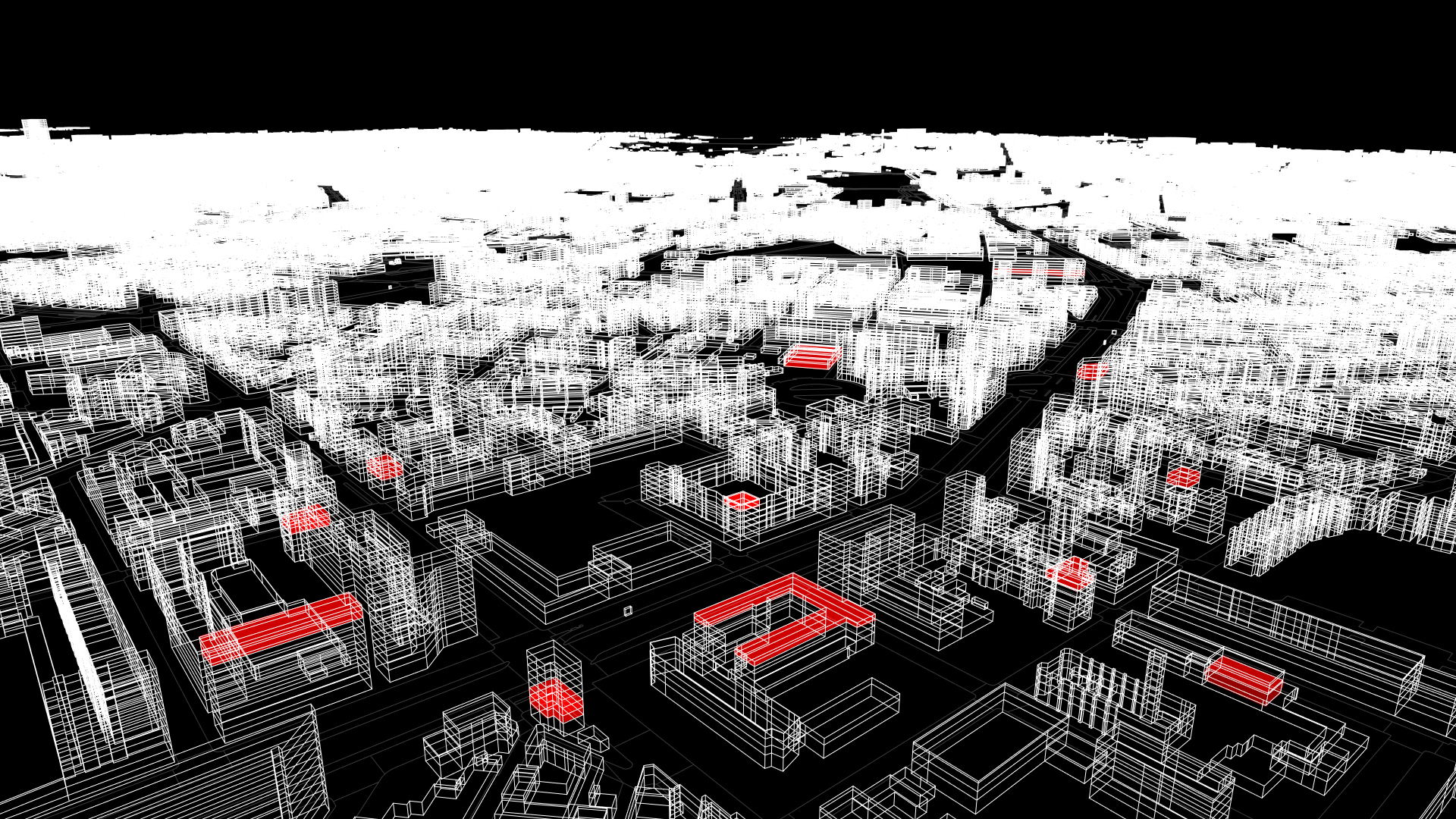
– Analisi dei cambiamenti nella morfologia urbana nel tempo attraverso il confronto tra dati aerei 3D raccolti in momenti successivi e i corrispondenti modelli digitali di superficie (DSM).
– Integrazione dei dati localizzati per monitorare l’effettiva presenza in un determinato luogo (ad esempio, tracciamento GPS aperto degli utenti, celle telefoniche, ecc.).
– Aggregazione di input co-generati combinati con dati georeferenziati attraverso strumenti di crowdmapping e mappatura mobile.
