
Abstract
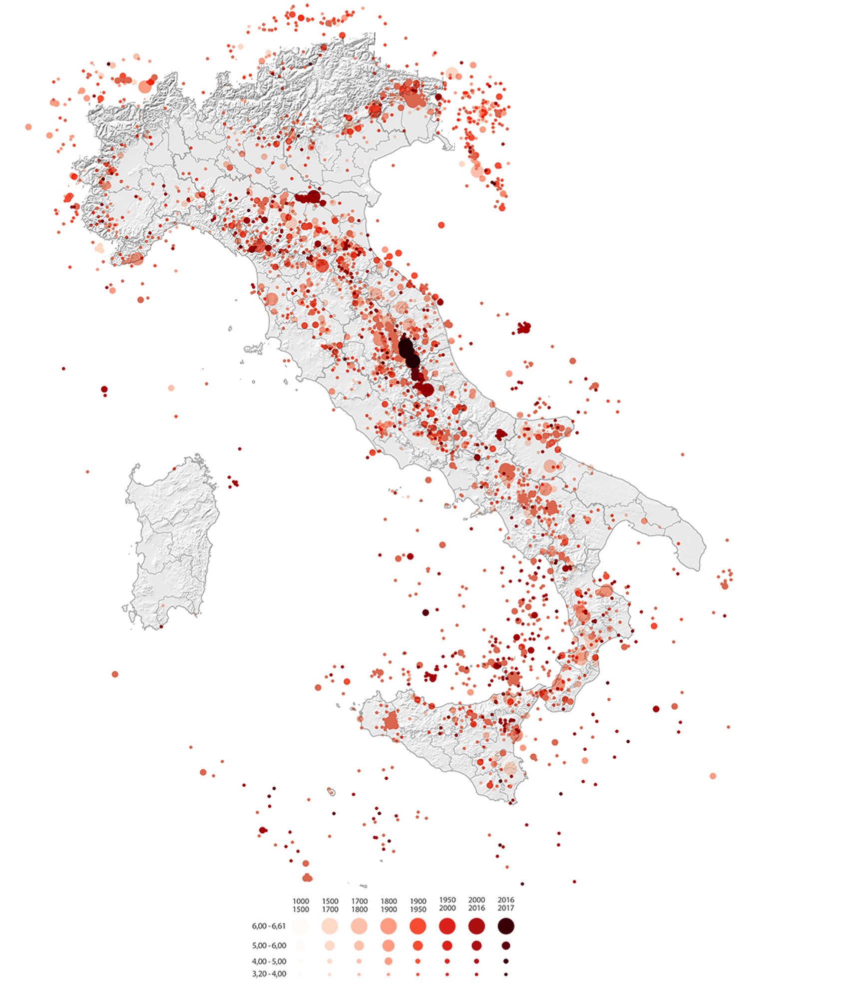
L’Italia è un territorio fragile per natura, cronicamente colpito da calamità naturali. Negli ultimi 50 anni è stata colpita da otto violenti terremoti, tre dei quali solo negli ultimi vent’anni nelle aree diffuse dell’Appennino centrale.
Le norme, i processi e le soluzioni per la gestione delle emergenze in Italia e nel mondo hanno allontanato la progettazione architettonica dalle soluzioni standardizzate e hanno trascurato le complessità territoriali.
Tutto ciò è accompagnato dalla lentezza dei processi di ricostruzione, che spesso richiedono dai 20 ai 30 anni dal verificarsi dell’evento. A partire dagli eventi sismici del 2016 nell’Italia centrale e osservando l’impatto spaziale degli edifici temporanei, questa ricerca riflette le relazioni tra insediamenti urbani di emergenza e permanenti e i loro effetti e trasformazioni in quel lungo periodo “intermedio” sulla ricostruzione urbana e regionale.
Quale ruolo assume il progetto di emergenza “temporaneo” nei territori italiani post-sismici e quali geografie produce? Come è possibile riprogettare futuri possibili per questa eredità provvisoria permanente?
In assenza di studi cartografici consolidati sulla questione, una prospettiva globale, sistemica e su scala nazionale, la tesi mira a riflettere sulla gestione temporanea. Le analisi geospaziali supportano le riflessioni e i metodi di mappatura definiscono e decodificano quei processi “teoricamente” provvisori (dalla scala geografica a quella insediativa). La prospettiva è quella di superare le operazioni di emergenza, passando dal concetto di protezione all’idea di incorporazione e coesistenza all’interno delle pratiche di progettazione dei rischi a lungo termine.
La ricerca propone la creazione di una banca dati geografica multiscalare e multitemporale supportata da un sistema informativo geografico (GIS), che consente di esplorare l’interazione tra gli strumenti geomatici come strumenti di progettazione urbana.
Attraverso una diacronia storica e un confronto critico tra casi italiani e internazionali, la ricerca mira a indagare la trasformazione degli insediamenti derivante da soluzioni temporanee alle azioni e ai processi di continuo spostamento, rifondazione e ricostruzione.
Uno dei risultati è la progettazione di un Atlante geospaziale (database) armonizzato delle soluzioni “temporanee”, che fornisce una panoramica empirica e accurata del fenomeno attuale nell’Italia centrale, misurato utilizzando una stratificazione di fonti e informazioni eterogenee, spesso non aggiornate.
Da lì, concentrandosi su specifici casi studio territoriali nell’area interna dell’Italia centrale, la tesi intende identificare potenziali scenari di trasformazione per le due metà della città, quella esistente e distrutta e l’eredità di quella nuova e temporanea.
Come possono coesistere nei futuri processi di ricostruzione nelle regioni e nelle comunità colpite da emergenze endemiche – naturali, economiche e antropiche – che sono sempre più ordinarie piuttosto che straordinarie?
